

AI for Earthquake Response
Challenge closed
From Orbit to Action: AI for Earthquake Response
Earthquakes strike suddenly and unpredictably, often causing widespread destruction to infrastructure, buildings, and essential services – putting lives at risk in an instant. In the critical hours following such an event, speed is everything. Rapid damage assessments can guide emergency responders to the hardest-hit areas, help identify ongoing risks, and support life-saving decisions when time is of the essence.
🏙️ The context
Earth Observation (EO) plays a vital role in crisis response by providing timely, accurate, and actionable insights. The International Charter ‘Space and Major Disasters‘ facilitates rapid access to satellite imagery following disasters, enabling responders to assess the full extent of damage from space. Through its global network of space agencies and satellite operators, the Charter delivers critical EO data within hours of an event to support rescue and recovery efforts.
Yet, despite access to high-resolution satellite imagery, damage mapping still relies heavily on human interpretation—a process that takes time, especially when every minute matters. Automating this process with artificial intelligence (AI) offers the potential to dramatically accelerate disaster response, generating actionable insights within minutes rather than hours.
But creating reliable AI for real-world disaster scenarios is no easy task. Models must be highly accurate, fast, and resilient to noisy, complex inputs. That’s where you come in.
Together, the ESA Φ-lab and the International Charter ‘Space and Major Disasters’ invite data scientists, AI researchers, students, geologists, and developers from around the world to join the AI for Earthquake Response Challenge – to build machine learning models capable of rapidly identifying post-earthquake building damage using EO data.
This is your chance to contribute to future innovation of humanitarian and disaster relief effort – using AI to help save lives when it matters most.
🛰️ One mission...
In the aftermath of a major earthquake, precision and speed are essential. Satellite imagery offers a unique vantage point to assess damage at scale – if paired with intelligent analysis.
This challenge tasks you with developing state-of-the-art AI models that can automatically detect damaged vs. undamaged buildings by analyzing high-resolution pre- and post-event satellite imagery.
The AI for Earthquake Response Challenge is a research-driven initiative that complements, but operates independently from, the Charter’s operational framework. Leveraging historical data from past activations, the Challenge aims to explore innovative approaches to rapid, automated impact assessment. High-performing solutions may inform the future evolution of the Charter’s operational processing chain, particularly within ESA’s cloud-based EO environment, the Charter Mapper.
🛰️ ...two phases!
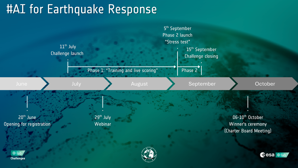
This challenge consists of two phases designed to allow adequate time for training with a robust dataset, while also simulating an operational disaster response pipeline:
Phase 1:
Duration: 11 July 2025 16:00 CEST – 05 September 2025, 17:00 CEST (8 weeks)
Participants will download a curated dataset from the ESA EOTDL (Earth Observation Test Data Lab). This dataset includes:
- Fully annotated earthquake-affected scenes for training
- Partially annotated scenes for both training and testing
You will build and tune your models to fill in the missing annotations. Your model should first be trained using the provided training data then ran on the partially annotated scenes to detect damaged and undamaged buildings based on the provided pre- and post-event high-resolution satellite imagery and accompanying building polygon files. The building polygon files are derived from available OpenStreetMap (OSM) datasets but have been carefully curated to reflect what is visible in the post-event satellite images. In the initial phase, 11 scenes will be released to you. Of these 11 scenes, 5 have been selected for the live scoring and will be provided to you only partially annotated. You will need to fill in all the missing building annotations, then a predetermined selection of these buildings will be used for the Live Scoring. You will not be informed which buildings will be used for the scoring; however, you can track your score on the public leaderboard. The remaining 6 scenes are fully annotated and are to be used only for training. You will not have to return these building files.
Phase 2:
Duration: 05 September 2025, 17:00 CEST – 15 September 2025, 17:00 CEST (10 days)
In the final 10 days, you’ll face the stress test. You’ll receive fully unannotated scenes from previously undisclosed earthquake sites.
These will include:
- Pre- and post-event Very High-Resolution satellite imagery
- A complete building polygon file without labels
Participants must now annotate all buildings in these scenes, demonstrating that their model can generalize and perform accurately in new, unseen geographic regions under real-world time pressure.
This phase simulates the operational urgency of a Charter activation, where trained models could make an impact in the delivery of actionable information in unfamiliar contexts.
We have set the dates of the stress test from Friday to the Sunday after, so you have two full weekends to work on it (a luxury which disaster response personnel might not have in real-life situations).
💡 The data
Don’t worry, you’re not alone. The ESA Φ-lab and the Charter will provide exclusive access to a curated archive of multi-mission, high-resolution satellite imagery collected from previous Charter activations. The dataset includes pre- and post-event imagery from satellites such as BlackSky Global, Gaofen-2, GeoEye-1, Kompsat-3 & 3A, Pléiades-1, WorldView-2, and WorldView-3.
All data is processed through the ESA Charter Mapper and will be made available via the Earth Observation Training Data Lab (EOTDL).