

AutoICE
Challenge closed
Challenge Overview
The Norwegian Computing Center, the Danish Meteorological Institute (DMI), the Technical University of Denmark (DTU), Polar View, Nansen Environmental Remote Sensing Center (NERSC) and ESA (European Space Agency), have created an extraordinary sea ice challenge, with the aim to bring together AI and Earth Observation players to address the challenge of “automated sea ice mapping” from Sentinel-1 SAR data.
The objective of the AutoICE challenge is to advance the state of the art of sea ice parameter retrieval from SAR data resulting in an increased capacity to derive more robust and accurate automated sea ice maps. In this challenge, we aim to push forward the new capability to retrieve multiple parameters, specifically, sea ice concentration, stage-of-development and floe size (form). The relevance of these capabilities should also be seen in the context of the upcoming Copernicus next-generation Sentinel-1 SAR mission and the Copernicus Polar Expansion mission CIMR (Copernicus Imaging Microwave Radiometer).
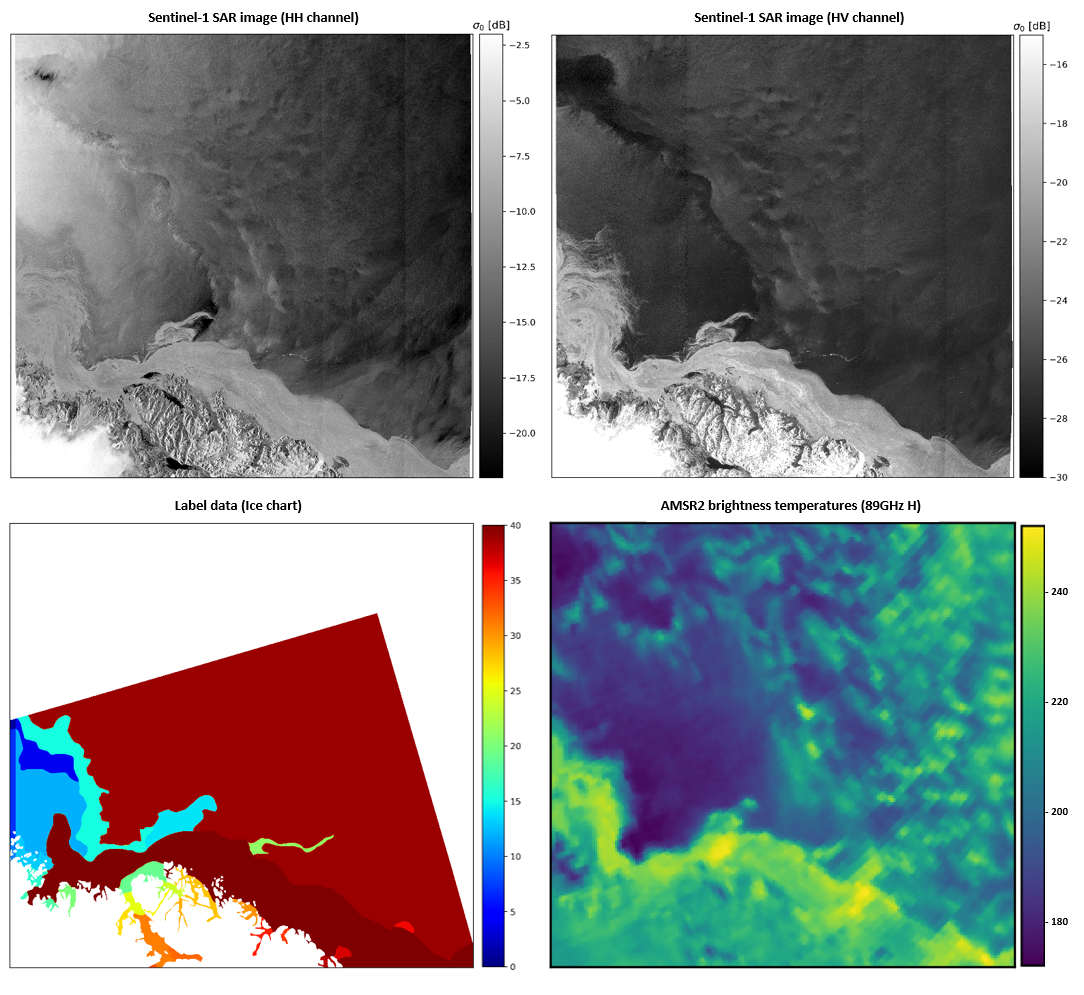
Manual ice charting from multi-sensor satellite data analysis has for many years been the primary method at the National Ice Services for producing sea ice information for marine safety. Ice analysts primarily use satellite synthetic aperture radar (SAR) imagery due to the high spatial resolution and the capability to image the surface through clouds and in polar darkness, but also optical imagery in clear sky and daylight conditions, thermal-infrared and microwave radiometer data from e.g. AMSR2. Ice analysts mention the spatial resolution of microwave radiometers as the primary limitation to use the data.
The traditional manual ice charting method is time-consuming and limited in spatial and temporal coverage. Further, it is challenged by an increasing amount of available satellite imagery, along with a growing number of users accessing wider parts of the Arctic due to the thinning of the Arctic sea ice.
The automation of the time-consuming and labor-intensive sea ice charting process has the potential to provide users with near-real-time sea ice products of higher spatial resolution, larger spatial and temporal coverage, and increased consistency.
Convolutional Neural Network (CNN) has great potential within automated prediction of sea ice in satellite images. Automating the process on SAR data alone is challenging. SAR images show patterns related to ice formations, but backscatter intensities can be ambiguous, complicating the discrimination between ice and open water, e.g. at high wind speeds. To tackle the challenges, the training dataset made available in this challenge contains Sentinel-1 active microwave data and corresponding Microwave Radiometer (MWR) data from AMSR2, to enable challenge participants to exploit the advantages of both instruments. While SAR data has ambiguities, it has a high spatial resolution, whereas MWR data has good contrast between open water and ice. However, the coarse resolution of the AMSR2 MWR observations introduces a new set of obstacles, e.g. land spill-over, which can lead to erroneous sea ice predictions along the coastline adjacent to open water. For more details on the training dataset, see the Data tab.
Check out our quick challenge video overview to learn the basics about the AutoICE Challenge
Important dates
- 23 November 2022: The AutoICE challenge is launched
- 17 April 2023 (4 PM CEST): The AutoICE challenge closes.
- 19 June 2023: Paper (4-page) submission deadline.
- 2 May 2023: Announcement of the 5 top-performing winning teams.
- May 2023: The Winners’ event will be held, with presentations from invited top-performing teams.
Organizers
Andreas Stokholm, Technical University of Denmark, Denmark
Nicolas Longépé, European Space Agency, Φ-lab, Italy
Tore Wulf, Danish Meteorological Institute (DMI), Denmark
Jørgen Buus-Hinkler, Danish Meteorological Institute (DMI), Denmark
Matilde Brandt Kreiner, Danish Meteorological Institute (DMI), Denmark
Anton Korosov, Nansen Environmental Remote Sensing Center (NERSC), Norway
David Arthurs, Polar View, Denmark
Roberto Saldo, Technical University of Denmark (DTU), Denmark
Rune Solberg, Norwegian Computing Center, Norway
Expert Panel
The AutoICE challenge has been designed in collaboration with machine learning and sea ice experts:
- Jan van Rijn, Assistant Professor in Automated Machine Learning, Leiden University
- Nick Hughes, leader of the Norwegian Ice Service, Norwegian Meteorological Institute
- Tom Zagon, sea ice expert at the Canadian Ice Service, Environment and Climate Change Canada