

MapYourCity
Challenge closed
Challenge Overview
Introduction
From street to a satellite view, the MapYourCity challenge takes a closer and differentiated look at our cities. With improved collaboration, exciting tools, and comprehensive datasets, now is the time for an innovative approach to better understanding our urban landscapes. One of the most predictive variables with relevance across a range of disciplines is “building age”, the chronological age or period that has elapsed since a house or structure was constructed. Thorough understanding of a city’s different building ages is crucial for assessing its overall structural integrity and safety, identifying renovation requirements, and appreciating the heritage or modernity of its infrastructure – from houses and apartment complexes to grocery stores and skyscrapers.
MapYourCity explores new solutions to detect building age using data both from a street-level and a bird’s view perspective. Merging satellite data with street view photos offers valuable insights and allows for AI-powered automated tools.
Want to dive right in? In this challenge, we provide you with all the necessary data so you can focus on developing your very own innovative and creative solution to pressing challenges. We will equip you with all the necessary tools, including:
- High-quality data: Gain firsthand access to cloud-free and curated very-high resolution (VHR) satellite imagery.
- Merged perspectives: Blend building footprints and georeferenced street views.
- Off-the-shelf AI capabilities: We’ve got you covered with deep-learning ready datasets, organised for training, testing, and validation.
- A community-driven ecosystem: Dive into our collaborative online repository, where datasets and models are up for exploration and improvement.

The Challenge
Each city holds history and evolution, and building age helps us to better map and comprehend both. Building age does more than just denote the years; it acts as a time capsule, revealing the architectural trends, construction techniques, and design philosophies prevalent during the era of a building’s creation. From the detail-driven and ornament-rich buildings of the Victorian era to the minimalist styles of modernism, each building age carries its own unique story, characteristics, and requirements.
More importantly, however, understanding the building age becomes particularly crucial when considering renovations or preservation efforts and maintaining a structure’s safety and integrity. Architects, city planners, preservationists, and homeowners alike use this information to make informed and thorough decisions about preserving the authenticity of a property while incorporating modern amenities and increasing the overall structural safety of a building. Wear and tear, structural issues, or outdated systems may require rapid and tailored action to prevent potential hazards or structural integrity failures and call for comprehensive monitoring of building age.
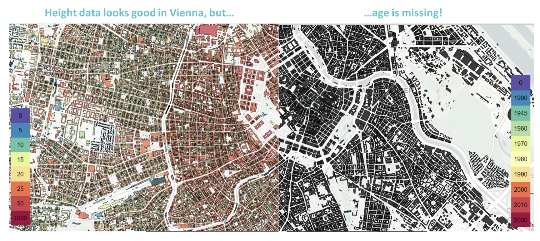
With ever-growing cities, thorough and structured monitoring becomes increasingly challenging. Manual sampling and monitoring from a street view can be a tedious and time-consuming task, further hampered by regular new (de)construction projects that constantly shift a city’s layout or obstruct clear visibility on buildings. Instead of being linked to perennial and easily traceable coordinates, many archives and datasets are often linked to street names and numbers that might no longer be current, making some manual building age databases obsolete. Due to their capability to offer an unobstructed and steady bird view, Earth Observation (EO) data could prove as indispensable tools to keep a stable view on our cities and their many building ages by allowing for a constant and coordination-based mapping of buildings.
By collecting, analysing and comparing large sets of data, building age enables comprehensive long-term monitoring and comparison, e.g., to compare the average building age of different countries or their respective cities within.
Artificial Intelligence (AI) offers capabilities to further automate these monitoring processes: From automated warning and reminder systems for potential structural weaknesses to completely automated processes of defining building age, AI-powered EO solutions could prove to be vital tools to increase efficiency and effectiveness of measuring a city’s building age and, with it, increasing the city’s overall safety and structural integrity.
This calls for new innovative solutions – and now it’s up to you.
How can “top-down” data from satellite imagery be combined with a picture of a building’s façade to classify its age? Could multi-modal deep-learning systems help in estimating the construction year of any given building using only VHR EO imagery? Can you help in streamlining the process of detecting a building’s age from a dataset of 35,000 entries across 5 countries of over a hundred-year timespan?
You are tasked with leveraging a heterogeneous dataset containing street-view imagery, Medium Resolution S2 imagery and VHR resolution top-view imagery to train a multi-modal deep-learning system capable of accurately estimating the construction year of any given building.
Your solution will be based on your very own dataset (with data provided by us) to give crucial information about buildings throughout Europe, including:
- Building footprints (in vector format);
- Information on the construction year;
- Street-level imagery depicting the façade (bearing information on its architectural style and condition);
- Cloud-free imagery from Sentinel-2 centred at the building location referring to a point in time after the building construction.
- VHR satellite image from the ESA Third Party Mission (TPM) Airbus Pleiades for one city pre-selected by the organising team.
This dataset shall then be used for the training of your very own multi-modal deep-learning system, which is ultimately capable of estimating the construction year of any given building using only VHR imagery as well as Sentinel-2 imagery.